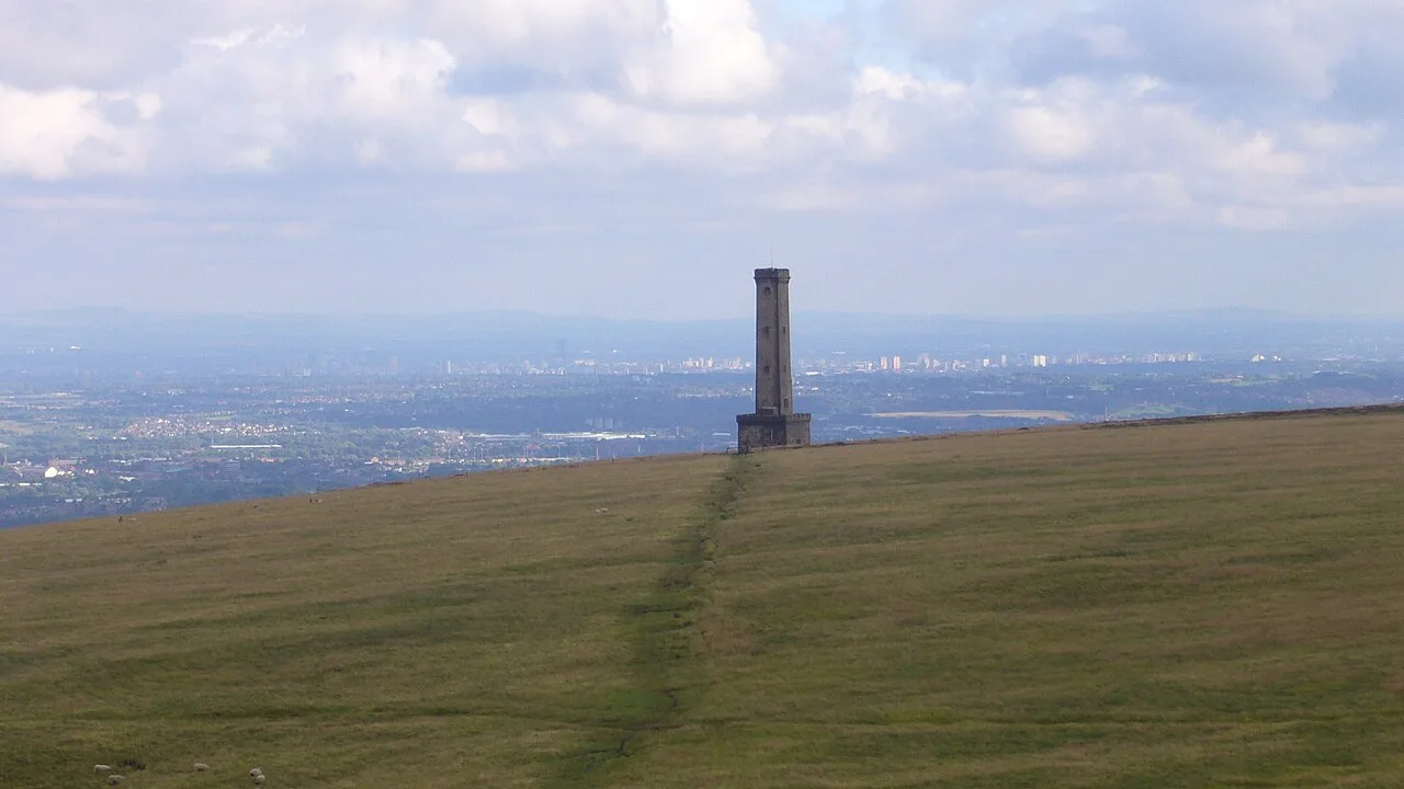

Peel Tower, Burrs and Prestwich Clough lead 12 walks near Bury checked 26 Oct: distances, start postcodes, buses, stiles and which routes take a buggy.
The walks near Bury most people look for are the Peel Tower circular on Holcombe Hill, the riverside path to Burrs Country Park, the Kirklees Trail along the old Tottington railway, and Prestwich Clough and Drinkwater Park down to the Irwell. Every entry was checked against the National Trust’s or Bury Council’s own route pages on 26 October 2026.
We have not walked these routes for this guide and nothing here is a rating. Distances, times, grades and start points are the publishers’ own: the National Trust for Holcombe Moor and Stubbins, and Bury Council’s self-led walks booklet, which the council put together with local walk leaders in 2020 and which GM Walking hosts. Each booklet route is a circle of no more than 3.5 miles with a bus stop near the start. Where a start point has changed since the booklet was printed, we say so.
Grades in the council booklet. Easy means suitable for beginners and buggies, mainly level and mainly on tarmac or paved surfaces. Fairly easy means woodland and off-road paths, mostly level with some slopes and occasional steps. Moderate means countryside paths and rights of way with steeper slopes, steps and possibly stiles.
Ramsbottom, Holcombe and Summerseat
Peel Tower circular, Holcombe
The National Trust’s Peel Tower circular walk is 1.9 miles (3 km), graded moderate, and takes 30 to 90 minutes. It starts at Lumb Carr car park, Lumb Carr Road, Holcombe, BL8 4NN, and climbs a track the Trust says is “uneven for its entire length and fairly steep” to the monument to Sir Robert Peel, the Bury-born Prime Minister, then returns past Harcles Hill and down Moor Road into Holcombe village. The first half is bridleway, the second footpath. On a clear day the Trust says you can see across Greater Manchester to the Derbyshire hills and the Cheshire Plain. Bury Council owns the tower and opens it on certain days only: ring Bury Tourist Information on 0161 253 5111 before you set off. There are no toilets. The Shoulder of Mutton is across the road where the walk comes back into Holcombe. Buses 472 and 474 from Bury stop at Holcombe Brook, about 400m from the car park.
Pilgrims Cross and Bull Hill, Holcombe Moor
For a longer day the National Trust publishes two moorland circuits: the Pilgrims Cross and Peel Tower circular, 5 miles (8 km), and the Holcombe and Bull Hill circular, 8 miles (12.8 km). The Trust says Holcombe Moor covers more than 1,400 acres, was designated a Site of Special Scientific Interest in November 2016, and is not suitable for people with limited mobility because of the terrain. Much of the moor is a Ministry of Defence training area. The MoD’s Holcombe Moor firing times page says that if red flags or lights are up, whatever the published times, you must not enter the training area; public rights of way on the rest of the moor stay open at all times, but blank ammunition and pyrotechnics may be in use. That page has not posted new weekly times since mid-2025, so look for the flags when you get there. Dogs must be on a short 2m lead from 1 March to 31 July, the Trust says, and kept under close control near grazing animals all year.
Stubbins Estate circular, Ramsbottom
The National Trust’s two-mile Stubbins Estate circular goes through Buckden Wood on the wooded hillside west of Stubbins. The Trust says to park on Stubbins Vale Road, BL0 0NS, where the walk starts. On the hillside above Stubbins Vale Mill is Tentering Tower, built in 1866 and now listed, which was used to stretch and dry newly made cloth. Dogs are welcome on a lead in the nesting season (1 March to 31 July) and near livestock. There are no toilets on the estate; Ramsbottom, a short walk south, has cafes and pubs. Ramsbottom station on the East Lancashire Railway is about 20 minutes’ walk from the start of several of the Trust’s routes.
Lammy Bank walk, Summerseat
Bury Council’s Lammy Bank walk is 2 miles (3.3 km), about an hour, and graded moderate: it crosses the river at Robin Road, goes through a kissing gate and up steps through woodland, and comes back down a cobbled path that the booklet says “descends steeply” to Waterside Road, with the East Lancashire Railway below. The booklet starts it at Summerseat Garden Centre car park, Railway Street, Summerseat, BL9 5QD, and returns along the River Irwell. The B1 bus serves Summerseat but not on Sundays or bank holidays. Summerseat’s new play area, opened by the council in 2024, is covered in our playgrounds guide.
Bury and Tottington
Irwell river trail to Burrs Country Park
The easiest walk out of the town centre. Bury Council’s figure-of-eight route is 3.3 miles (5.4 km), 60 to 90 minutes, and graded Easy, suitable for buggies. It starts at the Castle Leisure Centre, Bolton Street, BL9 0EZ, follows the River Irwell and National Cycle Route 6 to Burrs, loops past the duck pond, and comes back the same way along the riverside. The council’s Burrs page describes 36 hectares of woodland, wetland and ponds with a free car park, a playground and the Lamppost Cafe, open Wednesday to Sunday 10am to 4pm. Its park leaflet lists three Irwell Sculpture Trail works close together: David Kemp’s Waterwheel at the main entrance, Julie Edwards’ Stone Cycle and David Fryer’s Picnic Area. The Brown Cow, built as a farm in 1752, is the oldest surviving building on the site, according to the council. Burrs, Woodhill Road, BL8 1DA.
Kirklees Valley and the Kirklees Trail, Tottington and Greenmount
The Kirklees Trail follows the old Bury to Holcombe Brook railway, which opened in 1882 and closed in 1963, through the Kirklees Valley Local Nature Reserve. Bury Council’s short circuit is 1.5 miles (2.5 km), about an hour, graded moderate, starting at the nature reserve entrance on Brandlesholme Road, Greenmount, BL8 4DR, opposite the Hub Tea Rooms, and crossing the edge of the golf course. The 480 bus does not run on Sundays or bank holidays. For more, the Kirklees Valley Heritage Trail booklet takes a 4-mile route from Tottington bus terminus past the platform edge of Tottington station and concrete bases left by an experimental overhead electric power system of 1913 to 1918. It warns that parts are steep and unsurfaced and advises boots. The booklet says kingfisher and dipper can be seen on the brook.
Elton Reservoir and canal circular
Bury Council’s 3-mile (4.9 km) loop takes 60 to 90 minutes and is graded moderate. It starts outside The Wellington, Bolton Road, BL8 2PP (bus 471), goes down steps and through two short tunnels to the Manchester, Bolton and Bury Canal towpath, rounds Elton Reservoir, and comes back along the Daisyfield Greenway. The land around the reservoir is allocated for 3,500 homes in the Places for Everyone plan. The council has adopted a development framework that future planning applications will be judged against, with a nature park and new walking and cycling links, according to its Elton Reservoir planning page.
Chesham Wood and Clarence Park
A 2.8-mile (4.6 km) council route, 60 to 90 minutes, graded moderate, from Hoyles Park car park on Huntley Mount Road, BL9 6HY (buses 467 and 468). It climbs over a wooden stile near the M66, goes through swing gates into Chesham Woods, one of Bury’s seven local nature reserves, and crosses into Clarence Park, where the booklet suggests a stop at the Green Cafe. In wet weather it suggests leaving the park by Delamere Street and Chesham Road rather than following the grass edge. Clarence Park itself, with its lido and bandstand, is in our playgrounds guide.
Radcliffe, Whitefield and Prestwich
Outwood Trail and Outwood Country Park, Radcliffe
The Outwood Trail runs along a former railway line between Radcliffe and Outwood Country Park, which the council’s park page describes as more than 125 acres of woodland, meadow and playing fields on the River Irwell, with free parking at James Street North, M26 1AG, the old Ringley Road railway platform and a weir. National Cycle Route 6 passes through. The council’s 3-mile (4.9 km) booklet loop, graded fairly easy, adds the canal towpath, a large sculpture on the trail and a footbridge over the Irwell to Mount Sion Road. Its printed start, the Radcliffe Leisure Centre car park on Spring Lane, is out of date: that leisure centre has closed and its replacement in Radcliffe’s new Hub is due to open in winter 2026, as we reported.
Hurst Wood and Nuttall Wood, Stand
A short one, and graded Easy: Bury Council’s 2.1-mile (3.4 km) circuit takes about 50 minutes on “well laid” paths suitable for buggies. It starts at the corner of Old Hall Lane and Copper Lane, Stand, Whitefield, M45 7JU (buses 98 and 513), and loops through Hurst Wood and around Nuttall Wood. The booklet points out views towards the Giant’s Seat and Clifton Country Park from the bottom of the loop.
Prestwich Clough and Drinkwater Park
Bury Council’s 3.5-mile (5.6 km) route takes 75 to 90 minutes and is graded fairly easy, with woodland paths, footbridges and some flights of steps. It starts at the gates of St Mary’s Church, Church Lane, Prestwich, M25 1AN, a stop for buses 90, 92 to 95, 97, 98 and 484, drops through Prestwich Clough to Drinkwater Park and follows the east bank of the River Irwell before climbing back through the Clough. Next door, Philips Park, Bury’s largest local nature reserve, suggests two walks from its play area in the council’s leaflet, through ancient woodland to Dams Head Lodge, one carrying on to the Irwell near Clifton Aqueduct (1796) and the Thirteen Arches viaduct (1846), both listed. Its main entrance is on Park Lane, Whitefield, with limited parking.
Heaton Park lake and woodland walk
The flattest route in the borough booklet, graded Easy, though the park is Manchester City Council’s. The 2.9-mile (4.7 km) loop, 60 to 90 minutes, starts at the Metrolink entrance on Bury Old Road, Prestwich, M25 1JE (buses 90, 135 and 484, or the tram to Heaton Park), goes round the boating lake, up past the war memorial, and back by the Stables cafe and animal farm. The booklet’s map marks toilets near the stables and warns of vehicles and cyclists on the park roads. The park opens 8am to dusk. Parking is charged 10am to 5pm daily, from £1.50 for an hour to £3.50 for more than three, with Blue Badge holders free; the council’s Heaton Park pages carry the latest.
More routes in the council booklet
The same booklet has three more: Hollins Vale Nature Reserve from Unsworth Medical Centre, Parr Lane, BL9 8JR (2.8 miles, fairly easy, alongside the M66, with side paths it says are best left for drier months), Ainsworth Woods and Lodges from the Duke William, Well Street, BL2 5SQ (3 miles, moderate, stiles and a stretch of road without pavements), and Openshaw Park, Gigg and Springs from St Thomas’s Church, BL9 7EY (2.9 miles). All are on the GM Walking page.
How we chose
These are the routes people near Bury search for and that have a published, checkable description: the National Trust’s walks on Holcombe Moor and the Stubbins Estate, and the best-known of Bury Council’s self-led walks, with one or two in each part of the borough. Distances, times, grades, start points and bus numbers are the publishers’ own, and park facts come from Bury Council’s park pages and leaflets, Manchester City Council and the Ministry of Defence. We have not added anything we could not check. Run a Friends group, a cafe on one of these routes, or spot something that has changed? Email newsdesk@theburypost.co.uk.
For more ideas, see things to do in Bury, what’s on in Bury this month, our guides to Bury playgrounds and parks, cafes, pubs and Sunday roasts, or browse local businesses in Bury in our directory.
Frequently asked questions
What is the best walk near Bury for a view?
The National Trust’s Peel Tower circular from Lumb Carr car park in Holcombe, BL8 4NN, is 1.9 miles and graded moderate. The Trust says the views from the top take in Greater Manchester, the Derbyshire hills and the Cheshire Plain. The track up is uneven and fairly steep.
Are there buggy-friendly walks in Bury?
Three of Bury Council’s self-led walks are graded Easy, which the council defines as suitable for beginners and buggies on mainly tarmac and paved surfaces: the Irwell river trail to Burrs Country Park (3.3 miles), Hurst Wood and Nuttall Wood in Stand (2.1 miles) and the Park, Lake and Woodland walk in Heaton Park (2.9 miles).
Can you walk on Holcombe Moor when the red flags are flying?
Not in the range danger area. The Ministry of Defence says that if red flags or lights are up, whatever the published times, you must not enter the training area. Public rights of way on the rest of Holcombe Moor stay open at all times, though blank ammunition and pyrotechnics may be in use.
Have your say